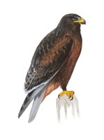
Ferruginous Hawk
Buteo regalis
Buteo regalis
This regal bird is the largest of our soaring Buteo hawks, a fitting raptor for the wide skies and windswept plains of the west. It soars
...- Climate VulnerabilityDerived from a published analysis by the National Audubon Society. Using information on projected range loss and potential range gain for each species, climate vulnerability was categorized as stable, low, moderate, or high.+3.0 °C ModerateGlobal Population SizeDerived from the Partners in Flight Avian Conservation Assessment Database. This database was developed with input from dozens of ornithological experts from ten countries and is managed by Bird Conservancy of the Rockies.USA & Canada Population SizeDerived from the Partners in Flight Avian Conservation Assessment Database. This database was developed with input from dozens of ornithological experts from ten countries and is managed by Bird Conservancy of the Rockies.IUCN Red List CategoryDerived from BirdLife International's assessments of extinction risk for the International Union for the Conservation of Nature (IUCN) Red List of Threatened Species which is the world's most comprehensive inventory of the global conservation status of biological species.


Ferruginous Hawk
Buteo regalis
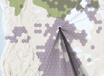
Species Migration

This map from the Bird Migration Explorer is made possible by the generous contribution of hemispheric weekly distribution data from eBird at the Cornell Lab, and a variety of hemispheric data sources for conservation challenges. Learn more
Data Providers
Conservation Challenges
This map from the Bird Migration Explorer is made possible by the generous contribution of hemispheric weekly distribution data from eBird at the Cornell Lab, and a variety of hemispheric data sources for conservation challenges.
The following partners contributed to the development of this map.Data Sources
How to contribute data to the Migratory Bird Initiative
If you are interested in sharing your data with the Migratory Bird Initiative, contact us at migratorybirds@audubon.org
To request information about the Migratory Bird Initiative
Requests for data should be directed to the contributing data holder or organization. If you're interested in something else, please contact us at migratorybirds@audubon.org
Map Layers
Conservation Challenges
See the footprint of select human activities and environmental changes across the hemisphere.
 Select a Conservation Challenge to view where this species is exposed to it throughout the year.

 Bird Species
 Locations
 Conservation Challenges